
NMEA Data Logging with the Rayfin Subsea Camera
NMEA data loggers are used to record oceanographic data from subsea cameras. They provide real-time information about the environment around the camera. This is important because access to the right data can make all the difference for oceanographers, marine scientists, and other offshore professionals. It helps them answer critical questions and make well-informed, data-driven decisions for research and the sustainable use of ocean resources.
Camera, multiplexer, and data logger
Multiple types of sensors and equipment are needed to gather high-quality subsea data. They all need to work together so collected data can be transmitted to the surface, recorded, and analyzed. When it comes to image-based subsea surveys, the Rayfin camera is the perfect choice. But not just because it produces high-quality digital stills and video. One of the lesser-known benefits of this industry-leading camera is that it’s also a multiplexer and can act as a data logger for NMEA sensors with built-in depth, tilt, and roll sensors.
What is a multiplexer?
A multiplexer, sometimes referred to as a mux, is used to integrate multiple signals on a single line of transmission. For example, since the Rayfin camera is a multiplexer, it is able to simplify multiple wired RS-485 connections into a single connection. This connection is over an Ethernet link between the surface and seabed. It’s a safe and reliable way to control multiple pieces of equipment and transmit data, whether it be recorded video, digitals stills, or NMEA data.
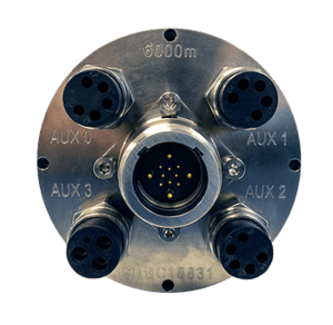
The back of the Rayfin camera, with multiple Auxilary ports, enables its multiplexer capability.
What is a data logger?
A data logger automatically records data over time. This data is received via a sensor and is time-synchronized, stored to be measured, evaluated, and validated. With the Rayfin, all information related to recorded video or digital stills from your survey, such as location and depth, is captured. With this data, you can analyze and understand the context in which your footage was collected.
What does NMEA stand for?
Officially NMEA stands for National Marine Electronics Association. This non-profit association was founded in 1957 and is dedicated to the advancement and education of the marine electronics industry. However, the terms NMEA and NMEA data tend to be used when referring to the standard data format the association created in the early eighties.
What is the NMEA data standard?
The NMEA data standard -- NMEA-0183 -- defines the electrical interface and data protocol for communications between marine instrumentation devices made by different manufacturers. In other words, this standard allows users to mix and match hardwares and softwares. As part of this standard, there is a set data format of sentences that carry information from the different sources like GPS or depth. With the Rayfin, each data string receives a time-stamp and is logged in parallel with internal camera sensors, video and images.
How does the Rayfin subsea camera work as a NMEA data logger?
Instead of requiring a separate data logger piece of equipment, the Rayfin records real-time information about the ocean environment around the camera. Example external sensors include depth, temperature, salinity, pressure, current speed and direction, and other environmental parameters.
It can also log topside sensor data such as GPS. When a GPS NMEA string is sent to the camera via topside software, the GPS’s latitude and longitude are time-stamped and stored in a CSV file in the “Data” folder on the camera. A new CSV file is created for each day. GPS data is also stored in JPEG EXIF which allows the photos to be geo-referenced in post review.
When a compatible sensor is attached to the camera, such as an altitude sensor or the built-in depth sensor, it will show the data on the camera software. There are two methods to send data to the camera:
Via RS-485 serial on the camera aux ports
Via UDP Ethernet from topside control software
What NMEA data sensors are built into the Rayfin camera?
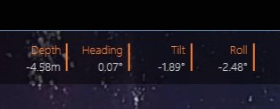
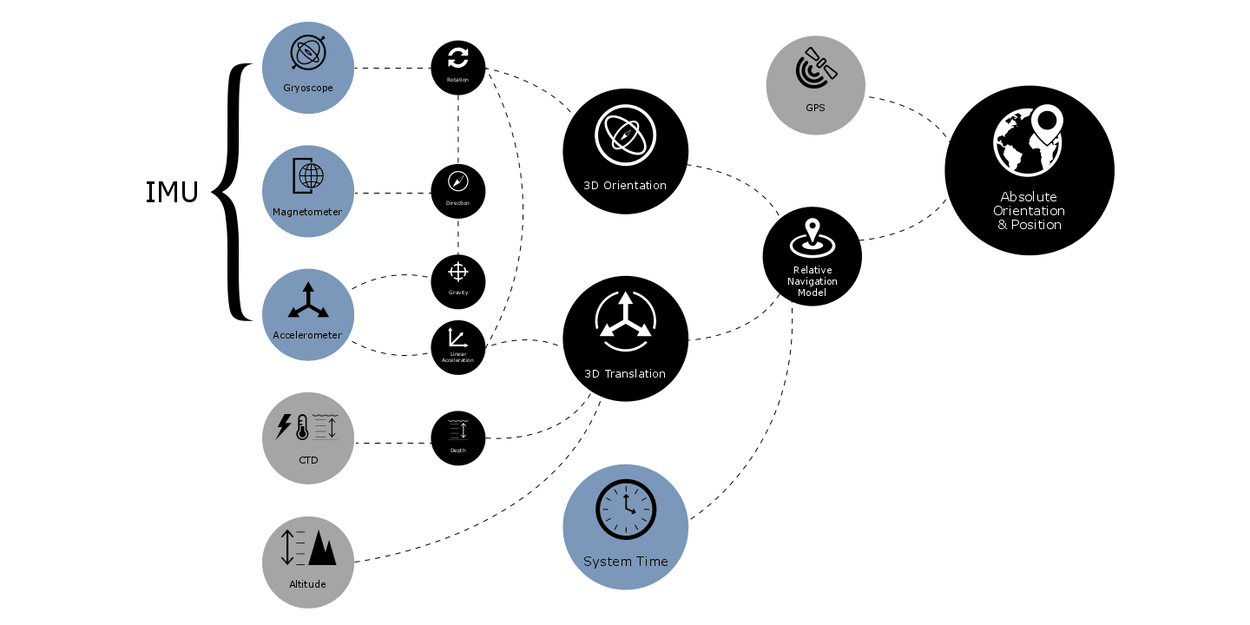
The Rafyin camera has built-in tilt, and roll sensors and has an optional depth and temperature sensor. It also contains an internal accelerometer, magnetometer and gyro (IMU) to track orientation.
What NMEA data sensors are compatible with the Rayfin subsea camera?
The Rayfin comes in different models and are all compatible with most common NMEA 0183 sensors. Compatible sensors include:
System clocks
Depth
Gyroscope
CTD
Altitude
USBL and GPS
Magnetometer
Accelerometer
Gravity
Linear acceleration
Rotation
Direction
Dependable, high-quality data
Reliably receive and save large amounts of video, image, and NMEA data from a variety of sources with the Rayfin subsea camera. The multiple functionalities of the Rayfin allows you to minimize and streamline your equipment and processes, saving you time and money. With a NMEA data-rich viewing experience, your benthic research and surveys will yield top-quality results while saving time and costs of having extra equipment.